By Lewis Bair, General Manager, Reclamation District 108
How critical are Sacramento Valley floodplains for a vibrant fishery?
A California Fish and Game Bulletin from 1930 gives us a clue. The report documents the Sacramento River commercial salmon catch declining from 6 million pounds in 1918 to less than 1 million pounds by 1927. The timeframe of the report may be the key to the answer because many of the usual suspects that people point to as the cause of the salmon declines had not yet arrived on the scene–invasive species, large rim dams, and Delta water export facilities wouldn’t be introduced into the system until years later.
What did occur during that decade was the taming and channelizing of the Sacramento River system, as the 1907 and 1909 floods ended the debate on how to solve Sacramento Valley flooding. The result was a system of levees and bypasses that was conceived and constructed to corral the mighty rivers. Riverbanks were raised with levees, and the historic sloughs that fed the floodplains with water and juvenile fish were either plugged entirely or replaced with weirs. The levees were designed to keep the main rivers within their narrow banks to move water quickly through the system. The weirs functioned to let high flood waters into flood bypasses only at very high flows, which occurred infrequently. The result was a significant reduction in the frequency and duration of flooding on the historic floodplains. This reduction in floodplain ‘activation’ was exacerbated by the development of drainage systems that graded and channelized the floodplains to rapidly drain the lands in the Valley.
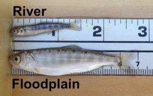
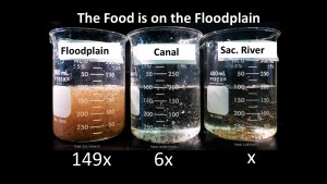
But why is a wet floodplain important for fish? New scientific research is showing us why. The health of a juvenile fish greatly influences its chances of surviving its journey to sea and back and returning as large adult salmon. Our current river system produces tens of millions of juvenile salmon every year, but they are not the ‘hefty’ juveniles that our historical floodplains once helped produce. The picture below, courtesy of California Trout, shows fish the same age, one was raised in the Sacramento River and the other on the adjacent floodplain. These ‘floodplain fatties’ grow so much faster and bigger because floodplain wetlands act like natural incubators, growing abundant food for the young fish to eat. When shallow floodwaters spread out on the floodplain for many days or better yet several weeks, they create near perfect conditions to grow bugs which are the base of the river’s food web. Levels of buggy fish food can be more than 150 times more abundant on the floodplain than in the River right on the other side of the levee as shown in this photo.
And it’s not just the young salmon benefiting from active floodplains. Waterfowl and shorebirds, as well as many other wetland species, benefit from the additional wetlands’ habitat. When water spreads and slows across the floodplain it also recharges critical groundwater. This is particularly important as climate change is increasingly delivering California precipitation as rainfall instead of snow. Improvements to the health of the river ecosystem also improve the path for permitting the flood system repairs and improvements. Healthy habitats mean healthy species populations which then reduces the regulatory pressure on the flood and water system. In essence more fish means a more secure water supply. Multi-benefit water management efforts that restore floodplains, provide habitat for multiple species and help rebuild the rivers food web all while improving flood protection and increasing are key to securing the reliability of our water supply.
But is it possible in 2020 to re-envision how our floodplains work on a large enough scale to make a real difference for fish as we look to the future?
The answer is “absolutely.” There is a perfect wave of collaboration forming between landowners, scientists, water users, conservation organizations and state and federal agencies, that all want to work together to develop a bold new approach to managing our floodplains for the future. This approach envisions keeping public safety as the top priority, but operating the system during winter months to grow food and fish by replicating the slowing and spreading of water onto the floodplains with a similar frequency and duration to historic flood patterns. The good news is that the physical modifications needed to implement this vision are pretty straight-forward. Many of the current weirs are in the same locations as the historical sloughs that once allowed water and fish to flow from rivers onto and off of the floodplains. These weirs can be upgraded with operable gates that will allow managers to restore much of the frequency and duration of the historic floodplain inundation that species are adapted to without jeopardizing public safety.
Fortunately, the historic floodplains along the Sacramento River became our overflow areas and bypasses, so they have not been paved over. The land-uses in these areas are largely farming of annual crops grown from April through October, which can now be complemented by more frequent wetting in the winter months outside the farming season. We recognize that more frequent floodplain flows during the winter months might affect certain land-uses such as wildlife refuges, hunting clubs, and private wetlands. This vision to reactivate floodplains must be designed and implemented in a way that respects and clearly accounts for and mitigates impacts to these land-uses. That’s why the collaboration amongst the many different groups and floodplain interests is so exciting and promising.
The footprint of this floodplain vision is truly large as shown in the map below; and the number of people and properties potentially affected is significant. But the benefits to public safety, the environment, and water supply reliability are too great to pass up. So how do we get this done? We are proposing the development of a landscape scale floodplain action plan which would lay out a path for the coordinated implementation of actions to re-wet the historic Sacramento Valley floodplains in a way that protects people and respects existing land uses. This proposal is shown below in more detail.
It will be a locally driven plan undertaken by a diverse team of landowners, scientists, water users, engineers, conservation organizations and state and federal agencies. Funding will be provided to support landowners to develop multi-benefit improvements to their land that supplement the vision, and avoid impacts to their property. Combinations of actions and improvements will be assembled into alternatives for evaluation. A hydraulic model will be created to evaluate alternatives so that benefits and impacts can be assessed. Alternatives will be refined and remodeled to address landowners’ questions, and the results documented in a final report that will also propose an implementation strategy to realize our collective vision.
This effort would be the largest re-visioning of the Sacramento Valley landscape in a hundred years. It won’t be easy, but it could be the most important thing we can do to protect and improve our Valley in a very long time. We encourage you to read our more specific concepts below and provide any thoughts and ideas to lbair@rd108.org.
Please click on both the map and proposal below for more details.
![]()
![]()


Keep dreaming big Lewis! American Rivers and lots of other conversation groups are right there with you!