Dale Hall, the Chief Executive Officer of Ducks Unlimited and former U.S. Fish and Wildlife Service Director, was in the Sacramento Valley this week, sharing his progressive thoughts on the wise use of the floodplain. His remarks were centered on water and he focused on a forward-looking approach where “tailored functional flows and non-flow measures serve multiple benefits (birds, fish and farms) and improve the health of the Delta, without pitting environmentally beneficial uses of water against one another.” In his view, these “functional flows” to spread and slow water out over the ground will better serve fish and birds in the long-term than a more simplistic “unimpaired flow” approach. He offered the following remarks and insights, which were previously shared with various state and federal agencies.
FLOODPLAINS: THE RIVER’S PANTRY
Throughout the world man has settled next to rivers for their water traffic, fish and wildlife productivity and the fertile grounds of the floodplains. Floodplains are among the most productive areas in nature and provide the supply of nutrients and food necessary to keep the river healthy.
In an unmodified floodplain, the ecosystem processes begin with the dropping of leaves in the fall by deciduous trees and shrubs that have evolved to have competitive adaptations that allow them to survive extended periods of saturated soils (anoxic conditions) in their root zones. These adaptations are commonly manifested as aerial or adventitious roots, buttressing with pores in the trunk that allow oxygen uptake in harsh conditions, and the ability to regulate chemical processes to convert harmful byproducts to non-harmful, organic compounds when the root zones are deprived of oxygen. These dominant factors of saturated (hydric) soils, adapted vegetation and hydrology are not only the biological factors that define highly productive wetland habitats, they are also the legal criteria in Clean Water Act Section 404 regulations to determine federal jurisdiction in unmodified habitats due to their importance to society.
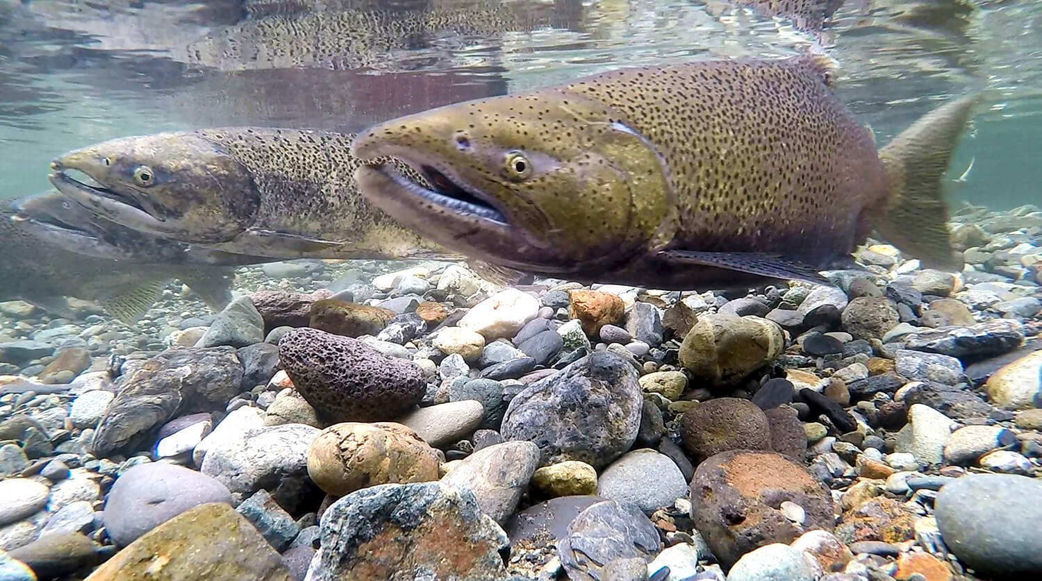
The significance of the floodplain adaptations is in the ability to provide the foundation and “cooking pot” for the food chain necessary to keep adjacent rivers alive and healthy. When leaves fall to the ground and subsequently become inundated with rising spring flows from spring melts and rainfall, the soaking action allows the onset of “leaching” of some of the nutrients, which helps to provide necessary food for phytoplankton that is beginning to emerge due to the warming of the water in the floodplain. The leaves are first colonized by bacteria and fungi. The decomposing detritus is ingested by micro and macro invertebrates, which make use of the bacteria and fungi as food and then discharge the remaining detritus to be re-colonized for further decomposition. This process has been compared to eating peanut butter on crackers. The significant nutrient comes from the peanut butter with the cracker serving predominantly as the vector of delivery.
As the floodplain vegetation slows the water flow, the first sediments that drop out of the water are the heavier sands, which help to build the natural banks of the river and also delay the outflows as water recedes and slowly re-enters the river. The next sediments to drop out are the silts and clays that are heavy with soil nutrients and recharge the floodplain. The decomposition of the detritus, and the ensuing phytoplankton and zooplankton, creates an explosion of life that includes macro invertebrates so essential to the survival of fish, waterfowl and the entire ecosystem. This overabundance of aquatic food sources serves to feed larval fishes that have emerged from their eggs and developed past the proto, meso and meta larval stages of post hatching embryonic development. Nature has provided this high concentration of food in order to accommodate the development of mouthparts for larval fishes, that must encounter food or die once the yolk material is completely absorbed. This is known as the “critical period” in the life of a fish, resulting in life or death depending on the young fish’s ability to encounter food.
As the water is held in the floodplain, accompanied by warming of spring, the floodplain holds concentrations of life that are found at no other time in the hydrologic cycle. Young fishes remain in the floodplain as long as possible and either drift or swim into the main river as the floodwaters recede. This huge influx of life is the literal food supply for the river and must sustain the fish and wildlife populations until the cycle can be repeated the following year, or years. However, in order for the river to receive this annual biological injection, the river must have access to the floodplain.
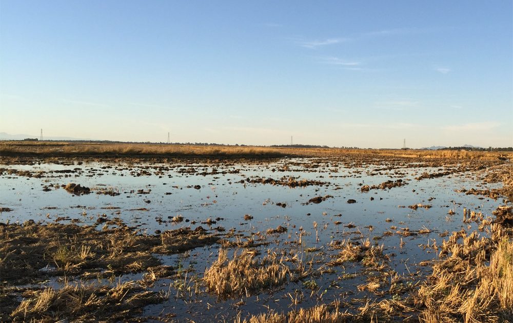
The Sacramento River evolved in the manner described above and benefitted from the annual flooding, nutrient (phytoplankton), invertebrate production and ultimate nursery for the fishes that survived in the river. But that cycle does not presently work for the Sacramento River because of the levee and water control structures that keep the rising water from entering the floodplain unaided by man. Instead, the floodplain forests have been cleared and the land planted with rice and other crops capable of withstanding saturated soil conditions. However, this does not mean that the floodplain can no longer function.
Instead, we look to the rice field stubble to provide the basis for nutrients, fungi and bacteria, micro and macro invertebrates and the ensuing explosion of life that still occurs: it is just not currently allowed to provide nursery habitat for salmon and smelt, nor is it encouraged to feed the river. Instead, we are faced with minimal introduction of food resources so necessary to sustain riverine species during the low water periods of the year. The lack of food creates numerous problems with the health and survival of both the salmon and smelt, with the most prominent one being possible starvation.
We believe this CAN be reversed and, if we desire to have healthy populations of salmon, smelt, and the remainder of Sacramento River ecosystem constituents, MUST be reversed. The fisheries research conducted by California Trout and others at the Knaggs Ranch and Conaway Ranch, as part of the Nigiri Project, has provided the best available science that proves the Sacramento River system evolved to function in this manner. It is imperative that we allow the food produced in the floodplain, along with the healthy growth of fish, to provide much needed biological relief to the sustainability of the River. This can only occur by having water available for the floodplain and encouraged to be used for that purpose.
WATER IS NOT HABITAT
One fact that is abundantly clear is that water alone is not habitat. Water is the catalyst and medium in which aquatic habitat can develop but, without nutrients and the food chain constituents, it can actually be detrimental to the very species it is intended to help.
The premise that sending higher flows of water downstream and into the Bay has not yielded positive results over the past decade. Additional flows at the wrong time can actually serve to flush out what minimal food supplies there might be in the river, including larval smelt that likely depend on slow flows and shallow depths in order to encounter food at the critical period. While well- intended, the scientific results of past efforts do not endorse this approach.
The best available science (CalTrout Nigiri Project) dealing with the diminishing populations of both salmon and smelt instead argues to allow the fish to use the floodplain for the nursery nature intended. The demonstrated increase in growth and health of salmon inside the flooded rice fields is clear evidence for more open connections to the river and, conversely, the inability to locate spawning and nursery areas for smelt should well inform that their needs are also in the River’s pantry.
Before more possibly destructive high flows are sent down the river with the intended purpose of assisting salmon and smelt, applied science dictates that the floodplain be given a chance to work the way it evolved.
FLOODED RICE GROUND
Each year, between 500,000 and 600,000 acres of rice are planted in the Sacramento Valley. Over 230 species are known to use California ricelands for habitat. Of that, 30 species are special-status wildlife: California Species of Special Concern, Federal Bird Species of Conservation Concern, California Fully Protected Species, California Threatened Species, California Endangered Species, Federally Endangered Species or Bald and Golden Eagle Protection Act.
Moreover, rice drain water contributes to the fall flooding of 40,000 acres of Sacramento Valley managed wetlands. Rice fields in the Sacramento Valley are specially- designated as Shorebird Habitat of International Significance – one of the largest special ecological sites of its kind in North America – helping support nearly seven million waterfowl (60 percent of all waterfowl in the Pacific Flyway) and 300,000 shorebirds.
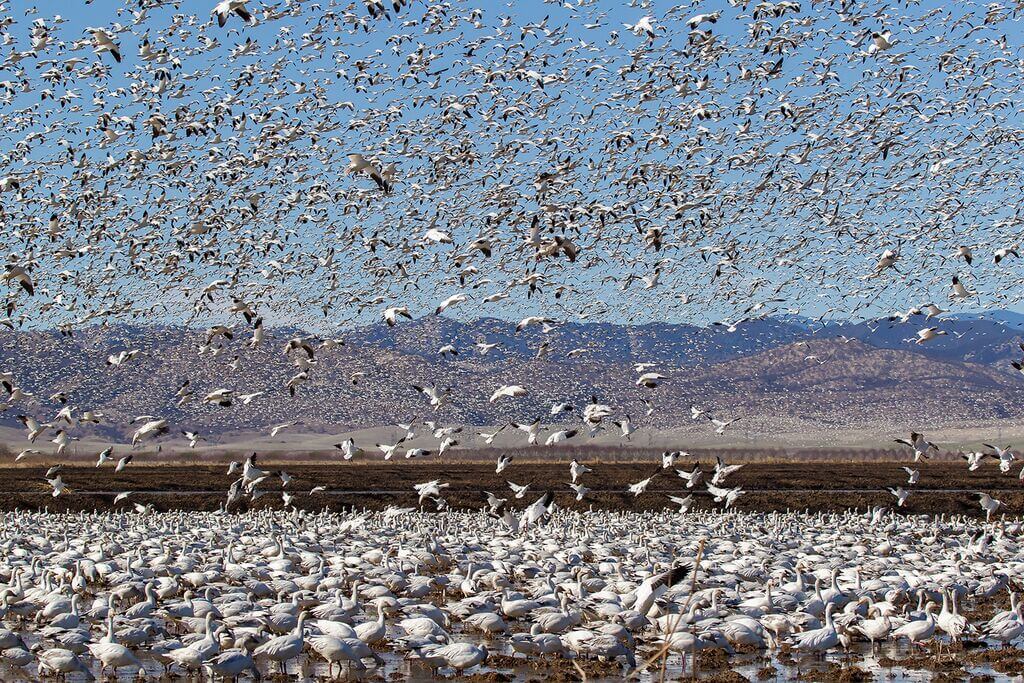
One acre of rice provides about two-thirds of the waterfowl food that is provided by one acre of managed wetland. There are about 350,000 acres of winter-flooded rice in the Central Valley. In terms of waterfowl food, this equates to about 235,000 wetland acres (350,000 x 2/3). Wetland restoration costs in the Central Valley, including the costs of land purchase, average about $6,500 per acre. Replacing the food now provided by rice with wetland-based foods would total over $1.5 billion. The amount of water needed to meet the winter-flooded rice objectives established in the Central Valley Joint Venture 2006 Implementation Plan is 425,000 acre-feet per year.
The provision of this water and the habitat values it provides is reliant upon the ability of Sacramento Valley water districts and companies to divert and deliver surface water resources year-round in accordance with their contracts and water rights.
MANAGED WETLANDS
It takes the combination of flooded agricultural lands (rice and to a lesser extent corn fields) and managed wetlands (which include federal wildlife refuges, state wildlife areas and private wetlands) to provide the food resources necessary to support the millions of waterfowl, shorebirds and other waterbirds that call California home for a significant portion of their annual life cycle.
The Central Valley contains approximately 206,000 acres of managed wetlands, covering just 5% of the historical 4 million acres of wetlands that once existed in the Central Valley. Of those remaining wetlands about 95,000 acres depend on surface water deliveries from the Central Valley Project, mostly located south of the Delta in the San Joaquin and Tulare Basins. The remaining wetlands are located (in order of acreage) in the Butte, Colusa, Suisun, Yolo, Delta, American, and Sutter Basins, and primarily depend on drain water and other “last in line” surface water deliveries from agricultural water districts.
The majority of managed wetlands in the Central Valley are located in large complexes of public wildlife refuges and privately managed wetlands, surrounded by many more acres of upland wildlife habitat, which together provide critical refuges for biodiversity in California. As one example, the Grasslands Ecological Area in the San Joaquin Basin comprises the largest contiguous wetland area west of the Rocky Mountains, and is recognized worldwide as a wetland of international significance. Public agencies and private landowners invested billions of dollars to protect and manage these areas for generations to come.
The Central Valley’s managed wetlands help bring species back from the brink of extinction (Aleutian Canada goose), prevent species from becoming critically endangered (giant garter snake and tricolored blackbird), and keep common species common.
Just as water districts rely on the continued ability to divert and deliver water to managed wetlands in the Sacramento Valley, the Bureau of Reclamation relies on the continued ability to release and divert water under its water rights to meet the needs of managed wetlands in the Sacramento and San Joaquin Valleys. In recent years, CVP operational restrictions have reduced deliveries of water to managed wetlands in the San Joaquin Valley at critical times of year. Cold water management in the fall delayed the delivery of water at the beginning of the managed wetland season. OMR restrictions in the winter greatly affected the total availability of water south of the Delta. And San Joaquin River inflow-to-export constraints made water unavailable for managed wetland irrigation in the spring.
The managed wetlands need water, both summer irrigation and winter flooding to provide their maximum benefits to birds. Likewise, the 300,000 acres of rice annually flooded during a “normal” winter is needed to ensure we provide the food resources necessary. The following two graphs illustrate this.
During “normal” years whereby wetlands are managed properly and typical rice acreage is winter flooded, we have enough food resources to maintain waterfowl populations throughout the winter months at North American Waterfowl Management Plan goals. However, during times of drought, which may be exactly the scenario that occurs routinely with the increased in-stream flows being considered, we can see that food resources may run short in the middle of winter. This is when bird numbers are at their peak and food demand is highest. This will likely result in substantial losses of birds that are reliant upon this Pacific Flyway habitat. For more information on the bird losses, please see the attached article titled “Potential Effects of Drought on Carrying Capacity for Wintering Waterfowl in the Central Valley of California.”
To see the Dale Hall interview in the Sacramento Valley, go to: Facebook.com/SacValleyCA
For additional insights into nature’s pantry, please see the short Cal Trout film No Going Back.


