By Kelly Petersen, Butte County Water Resources Scientist
Each spring groundwater levels are measured throughout the Sacramento Valley, including here in Butte County. As Watching Groundwater Level Recover in the Sacramento Valley noted earlier this year, water resources managers, Groundwater Sustainability Agencies (GSAs) and landowners throughout the Sacramento Valley are watching groundwater levels and quality to see how the aquifer systems will recover on the heels of some very dry years where there has been little surface water in certain parts of the Valley. We are seeing some encouraging trends on aquifer recovery in Butte County with the wet year and we will continue to monitor and collect important information to ensure the sustainable management of our groundwater resources.
In Butte County, groundwater levels have been measured by either Department of Water Resources (DWR) or County staff during the spring, summer and fall seasons since the mid-1990s, providing Butte County one of the most extensive data sets and groundwater models in California.
Each monitoring well tells its own story since wells vary in depth, well type and use (irrigation, domestic, dedicated monitoring wells and municipal and industrial), location and surrounding conditions. However, spring levels overall, give a big picture view of basin conditions and how they change throughout the County over time.
 Monitoring approximately 140 wells throughout the County provides trends in water levels and provides a better understanding of not only how water levels change within a year, but also many years within a specific well. This also allows us to determine the rate of change for each well and understand how many feet per year (on average) water levels are rising or falling over a set amount of time. This can give us insights as to areas that may need to be evaluated further and monitored more closely, and/or areas that could be good candidates for targeted projects and management actions that improve groundwater levels and storage.
This work, and the resulting data, helps track how groundwater levels fluctuate at each of the wells in response to weather conditions and water use.
We spend significant time working to understanding the data—but the big question is, “how have groundwater levels responded after the wet spring of 2023 in comparison to the dry spring of 2022,” which was the third year of a three-year drought. Across the board, all the wells in the groundwater subbasins that the County monitors (Vina, Butte, and Wyandotte Creek) have shown increased groundwater levels when compared to spring 2022 numbers. This was expected, especially given the dry conditions in 2022 and the wet conditions of 2023.
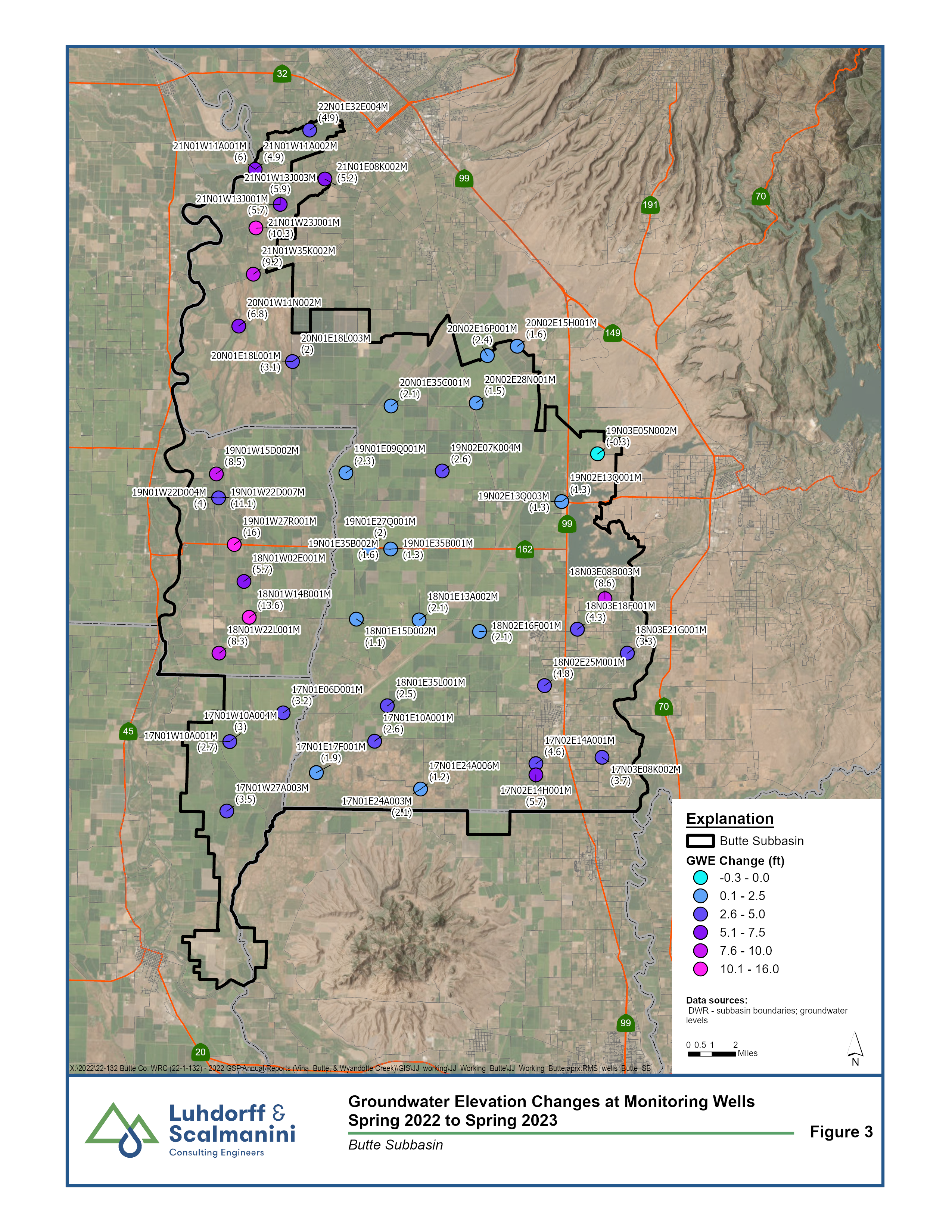
The map below shows the wells that are monitored as part of Sustainable Groundwater Management Act (SGMA) compliance in the three subbasins. Each circle’s color indicates the degree of Groundwater Elevation (GWE) change from spring of 2022 to 2023 for that well, based on the information in the legend. In the Vina and Wyandotte Creek Subbasins, groundwater levels rose on average about three feet between the 2022 and 2023 spring seasons. In the Butte Subbasin groundwater levels rose on average about four and one-half feet between those two seasons.
This rise in groundwater levels from 2022 to 2023 is primarily due to the influx of precipitation we have had since mid-November 2022; not just here on the valley floor, but also in the high-elevation mountains that feed the rivers, creeks, and streams in our watersheds. These surface waters have had above average flows contributing to a full Lake Oroville and more ‘hang time’ in our area as the snow continues to melt, keeping these waterways fuller for a longer duration. Surface waters have continued to add volume into our aquifers, raising groundwater levels. These excellent 2023 surface water conditions have also resulted in full allocations for those who have water rights to divert and use water from the rivers, creeks and streams, which in turn reduces the need to use groundwater to meet the existing water demands.
Changes in precipitation from year to year confirm that we continue to experience great extremes in California hydrology from historically dry to historically wet conditions within just a few years. These big swings in the surface water system lead to moderate annual changes in the groundwater system in Butte County. Managing both surface and groundwater resources with the reality of these extremes will continue to be our challenge and opportunity.
Our subbasins, particularly the Vina Subbasin, would need at least a few prime hydrological condition years to fully bounce back to the point where inputs into the aquifer balance the extractions we have observed over the last 20 years. The good news is that with the groundwater sustainability plans we know the scale of the work that needs to be done. The GSAs are annually tracking these conditions on a much finer scale to determine how well they are doing at managing groundwater sustainably. The GSAs also summarize the monitoring results in an easy-to-read-and-digestible Annual Report that shows water level comparisons from year to year. Groundwater extraction and storage volumes are shown graphically, in an attempt to make the complex datasets easier to visualize. The Annual Reports are valuable to the GSAs and the County for planning and project development purposes. Using the information reported in each subbasin, the Butte County Department of Water & Resource Conservation then synthesizes the information and provides a county-wide groundwater status report to the Board of Supervisors. This County report continues to provide decision-makers and stakeholders with a broader perspective on the status of this shared resource. It is designed to be a quick read of the highlights from all three groundwater subbasins, trends over time, things to track over the next year, and a description of current efforts underway to continue to improve the County’s groundwater resilience.
We encourage you to look at this information on groundwater levels and hydrological conditions on our website at: Groundwater Levels | Butte County, CA (www.buttecounty.net/1189/Groundwater-Levels).


