By Casey Gudel, Client Relations & Project Manager Land IQ
Understanding what is happening on the surface of the ground is important to a range of groups including local and state governments, water managers, commodity organizations, and growers alike.
As a firm deeply rooted in land-based science, Land IQ realized more than fifteen years ago that there was a significant gap in available data to understand just this. At that time, the only resources available were the Department of Water Resource’s (DWR) County Crop Reports, which were not conducted statewide or on an annual basis, or the United States Department of Agriculture’s Cropland Data Layer, which does not consider California’s diverse cropping patterns.
Seeing how better land use data could provide more accurate analysis, Land IQ sought out a solution that included integrating crop production knowledge with detailed ground truth information and multiple satellite and aerial image resources to conduct remote sensing land use analysis at the field scale.
Land IQ began its mapping journey with a pilot study for the Almond Board of California (ABC), mapping almonds in Madera County in 2011. Two years later, they mapped Madera County again and then followed up with the first ever statewide mapping of almonds, walnuts, pistachios and dried plums through a Specialty Crop Block Grant with ABC, the California Walnut Board, California Pistachio Research Board, and the California Dried Plum Board in 2014.
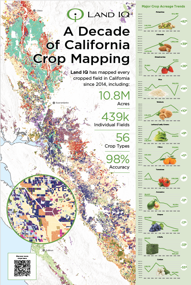
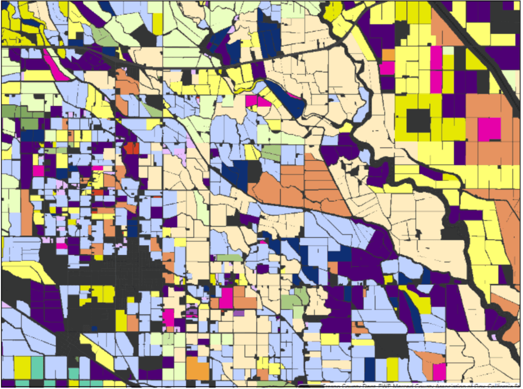
What started as just four commodities, turned into numerous others, and set the stage for mapping all crops across the entire state of California, for the first time ever. The original map product for DWR classified the 2014 main growing season, covering over 9 million acres of agriculture, over 572,000 acres of managed wetlands, and more than 4.5 million acres of urban, resulting in over 350,000 individually classified polygons with a minimum field size of two acres reaching 96.6% accuracy.
Throughout this experience, Land IQ has continuously sought areas for innovation, technological advancement and improvements in mapping efforts, offering refinements to mapping classes and expanded mapping features in every mapped water year.
One such innovation started with 2018 water year, where Land IQ began mapping all cropping, including fields that had multiple crops within a water year. This resulted in the continuous mapping of the state of California. With the release of the 2023 data, users now have 5 years of continuous mapping available. The data also includes 56 crop classes, permanent crop age, up to four crop classifications in fields where multi-cropping occurs, the percentage of the field cropped, and peak growth dates.
DWR requires an accuracy of at least 95% on each mapping year. Land IQ has exceeded this requirement, achieving around 98% each year since 2018. A key component in determining the accuracy of remote sensing approaches is referred to as ground truth data. Ground truthing allows the user to check the results of the remote sensing analysis against the real world by collecting real features and materials on the ground. The collection of this data enables the user to both calibrate the models used and independently validate the accuracy of the results.
 Land IQ has a fundamental belief that the accuracy of any product is a result of the high-quality data collected. For the most recently released data set, covering Water Year 2023, over 15.6 million acres were mapped with an accuracy of 98%, which was the result of the collection of over 85,000 data points collected.
At the conclusion of each mapping year, Land IQ reviews accuracy statistics by crop type to develop the best routes for collecting the most meaningful data and achieving the highest accuracies.
Land IQ’s mapping data, published by DWR, has become recognized as one of the most valuable data resources available in California’s water-limited state to understand resource use and planning. The reach of these data is extensive, fulfilling the needs of DWR’s internal team as well as the needs of external users for purposes ranging from water resources planning and modeling, nutrient management compliance and planning, species habitat management, economic modeling, land use forecasting, and climate impact forecasting, to name a few.
VIEW COLUSA FARM SHOW PRESENTATION & CROP SPECIFIC SLIDES
To learn more about Land IQ’s mapping and to access the data, visit www.landiq.com/land-use-mapping.
Land IQ is a specialized agricultural science and remote sensing firm that pairs scientific knowledge of agronomic, native plant and land systems with advanced remote sensing technologies, custom modeling, and analytical methods to develop powerful and cost-effective client solutions. Their focus is on large-scale landscape systems and management solutions. Their team is equipped with extensive experience in crop production systems, soil and agricultural sciences, native ecosystems, remote sensing and geospatial analysis, data management, agroclimatology, irrigation technologies, and land and water resources scientific and regulatory issues.


