By Brett Storey, Principal Management Analyst
Environmental Utilities, Placer County
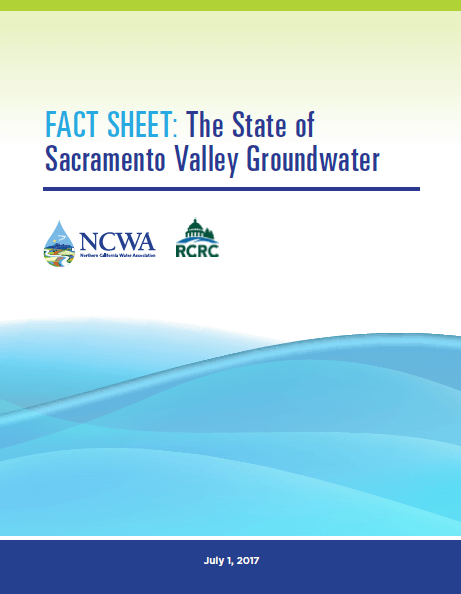
During the recent drought in California, groundwater aquifers in West Placer County fared much better than other areas of the state. From Spring 2012* to Spring 2016, water levels dropped only about four to five feet in the southwest corner of the County where the lowest groundwater levels occur. Starting in the 1950’s, this area experienced over 55 feet of groundwater level declines as shown in Figure 1. This major downslide came to a halt around 1980, when the City Roseville and many water providers to the south (in Sacramento County) gained access to surface water from Folsom Lake and allowed conjunctive use programs to be successfully implemented, primarily by Sacramento Groundwater Authority (SGA) and its member agencies.
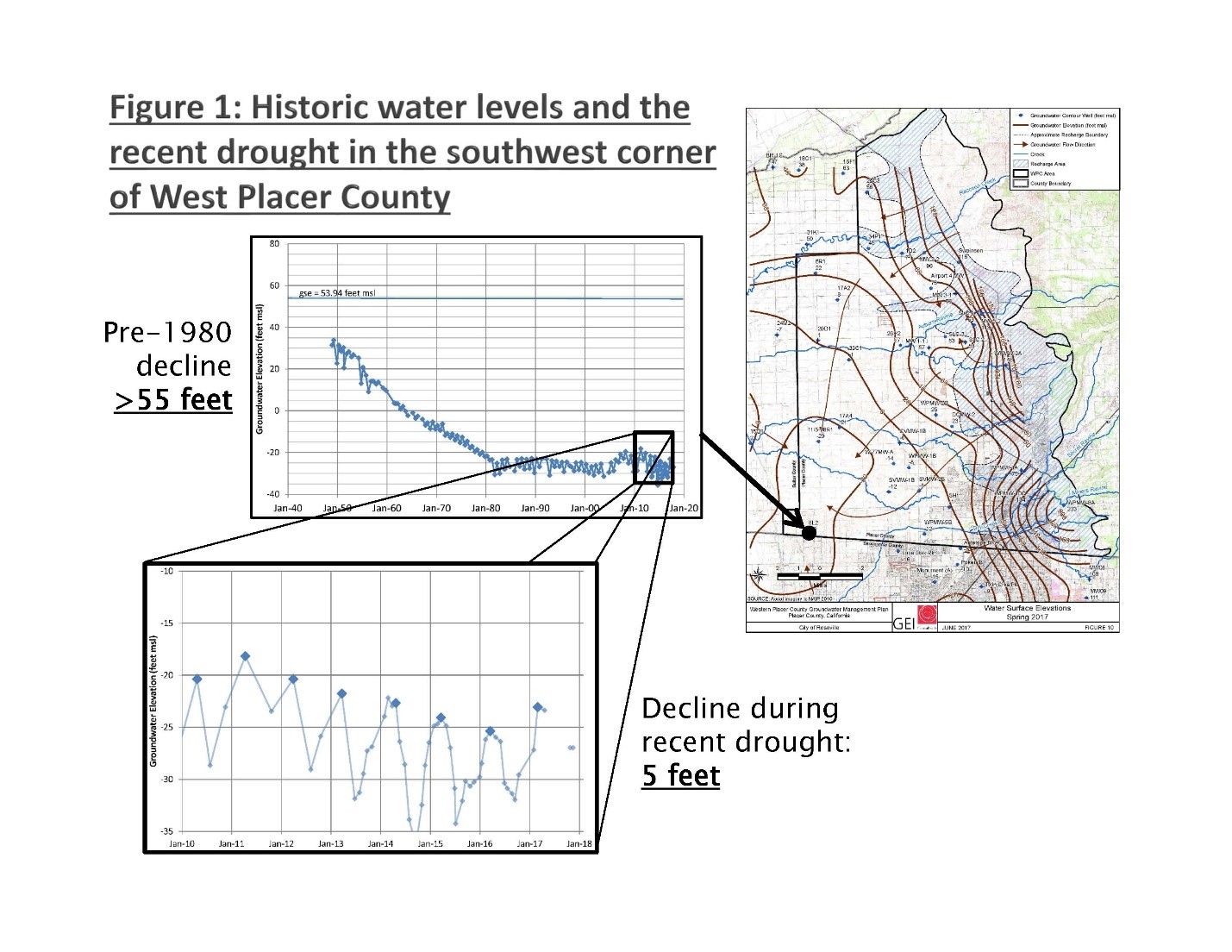
Not only do water level declines during the recent drought pale in comparison to historic, but the wet winter of 2017 has brought the region back on the upswing. This same southwest corner of the County has recovered by about 25% of the drought-related declines by spring 2017, and still rising. Meanwhile, in the eastern portion of the basin, along the foothills of the Sierra, many wells never declined at all due to the drought and the 2017 rains along with reduced pumping have filled aquifers above where they were prior, if not higher as shown on Figure 2. The filling of the aquifers in these areas bodes well for the region as this “mountainfront recharge” area (shown in blue on Figure 2) approximates the area where permeable soils near the ground surface are interconnected to the deeper portions of the regional aquifers. These natural conditions allow small streams to contribute large amounts of recharge to groundwater aquifers. The West Placer Groundwater Sustainability Agency (WPGSA) is performing studies to better understand the nature and amount of contribution of these small streams in the mountainfront area. Additionally, the WPGSA is identifying lands in the eastern portion of the basin that can potentially be used for recharge during times of excess flow to take advantage of these natural recharge conditions, dependent upon land owners willingness to participate.
Water that recharges into the ground at the mountainfront eventually makes its way west and south, but that takes time. A more immediate approach to encouraging recharge and “banking” water underground at the locations where it is needed is to use Aquifer Storage and Recovery (ASR) wells. These specially designed and operated wells essentially run their pump in reverse to store water underground during wet years, then extract it during dry years. The City of Roseville has drilled a number of these wells, obtained permits and performed successful pilot testing. Other water providers in the region have been looking at this approach. ASR has the distinct advantage of getting the water directly into the deeper parts of the aquifer, past any surface clay layers or other conditions that might limit infiltration when water is simply spread on the ground surface. The feasibility of ASR as a regional conjunctive use strategy does have regulatory and financial hurdles (i.e. they are expensive to build and it takes energy both to store and extract the water). However, the State Water Resources Control Board has taken measures to clarify the permitting process by issuing a general waste discharge requirement for ASR projects.
* Note that 2012 was used because many of the dedicated monitoring wells used by the WPGSA were drilled in 2011 and therefore 2012 provided the first recorded “spring-high” water level at those sites.